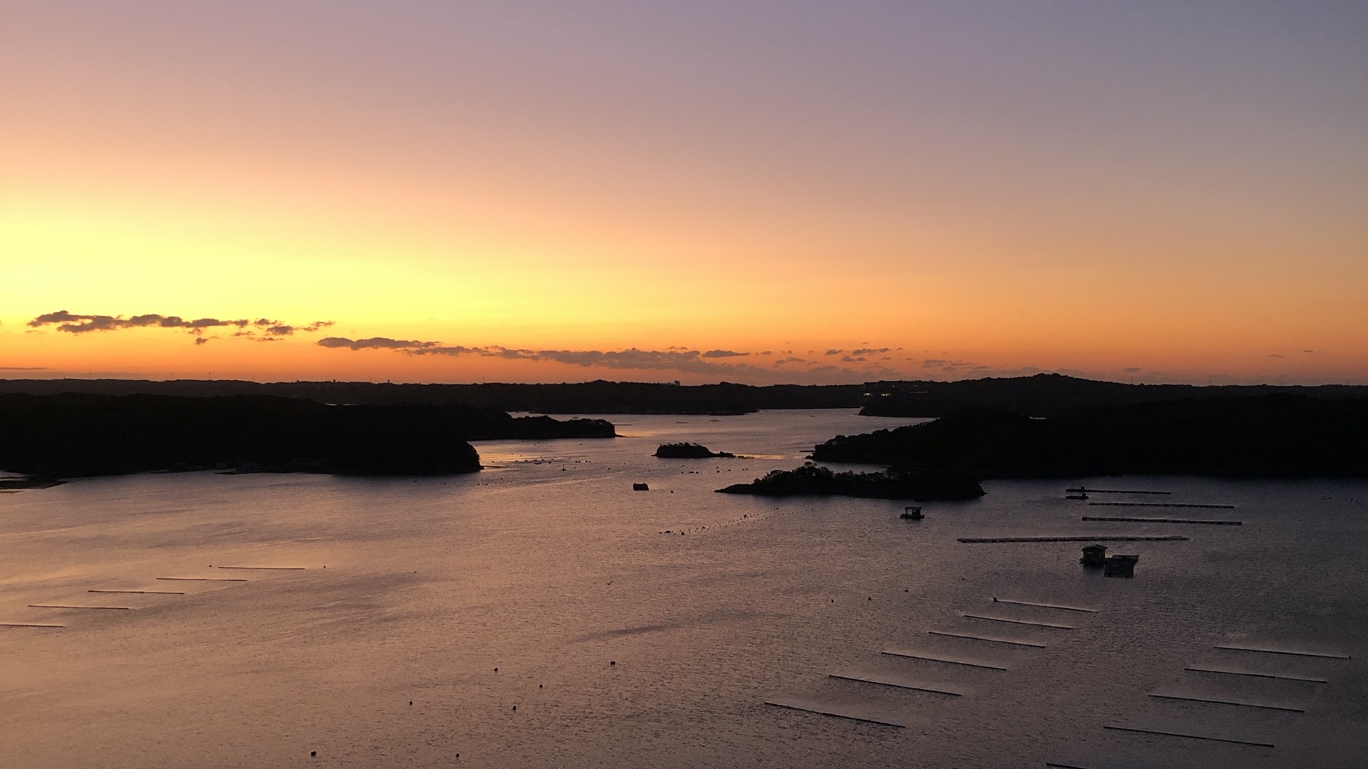
Before coming to Iki on the Remote Islands Exchange program, I didn’t know “remote islands” were. I mean, all of Japan is islands right? In English there is lots of content on “Japanese islands that are remote” but not much on “remote islands”, or ritō, as a singular concept. Now that I live on one of those remote islands, I started to dig in.
How many islands?
Quick quiz! Name the islands that make up Japan!
🤔 Well, there is the main island Honshu which has most of the population and the big cities like Tokyo, Osaka, Nagoya, and Kyoto. Hokkaido is the big one in the north famous for potatoes and the Ainu indigenous peoples. Tucked under Honshu is Shikoku connected by that really long bridge and the 88 temple, 1200km walking pilgrimage. Then, in the southwest there is Kyushu, from which it is a short ferry ride to Korea. That’s the major four islands. Then of course there is Okinawa, the old Ryukyu Kingdom which was only returned to Japan by the American military in 1973. Those are all the major islands, but there are obviously many more. Like the Senkaku Islands that Japan and China are fighting over, or Takeshima, which the Koreans dispute as Dokdo. The Russians have some claims on the Kuril islands in the north. Then there is that bunny/poison gas island and like 11 cat islands.
Being a “stratovolcanic archipelago” Japan has a lot more islands than you can likely name. In fact, there are 6,852 at the last official count (UPDATE! Japan doubles its islands). The vast majority of these are uninhabited, but there are 416 islands[1] where human beings (and cats probably) reside. But they are all important for Japan. I will go into that in a future post, but today I would just like to introduce you to the concept and the geographic context of the ritō.
Breaking down the regions of Japan
The most basic subclassification of Japan that most are familiar with would probably be the four major islands plus Okinawa. That is simple geographical categorization. If you spend any time here, you quickly learn about the eight regions of Japan (eg. Kansai, Kanto, Chūbu, etc.). These have analogues in other countries (eg. the Prairies, the Midwest, the South), and are more known for cultural differences such as food or speech patterns (eg. the strong Kansai dialect, or the fact that Tokyo has bland food — that’s a dig from me who used to live in Kansai!). There are more ways to slice up Japan but the newest to me has been the demarcation between “mainland” (hondō 本土) and “remote islands” (ritō 離島). The word hondō is made up of two characters:
- hon 本 for “real” or “main”
- dō 土 for “soil” or “land”
Hondō refers to the four main islands.[2] The other 6,748 islands are ritō, generally translated as “remote islands”:
- ri 離 for “separate”, “apart”
- tō 島 for “island”
The fact is, ALL of Japan is made of islands, and depending on the context, this demarcation can get a little fuzzy. Nowadays the ritō are the responsibility of the Ministry of Land, Infrastructure, Transport and Tourism (MLIT) but certain island groups come under different jurisdictions (more on that later).

It is important to note that to get into the official count of 6,852 an island has to have a perimeter of at least 100 metres and has to be able to support life — ie. it cannot just be a rock. Which brings us to another distinction between islands, that of yūjintō 有人島 and mujintō 無人島: inhabited and uninhabited islands. 95% of Japan’s islands are uninhabited.
Below is a map from the MLIT that organizes all of the 257 inhabited remote islands into regional clusters. I added English labels and the number of islands per region:
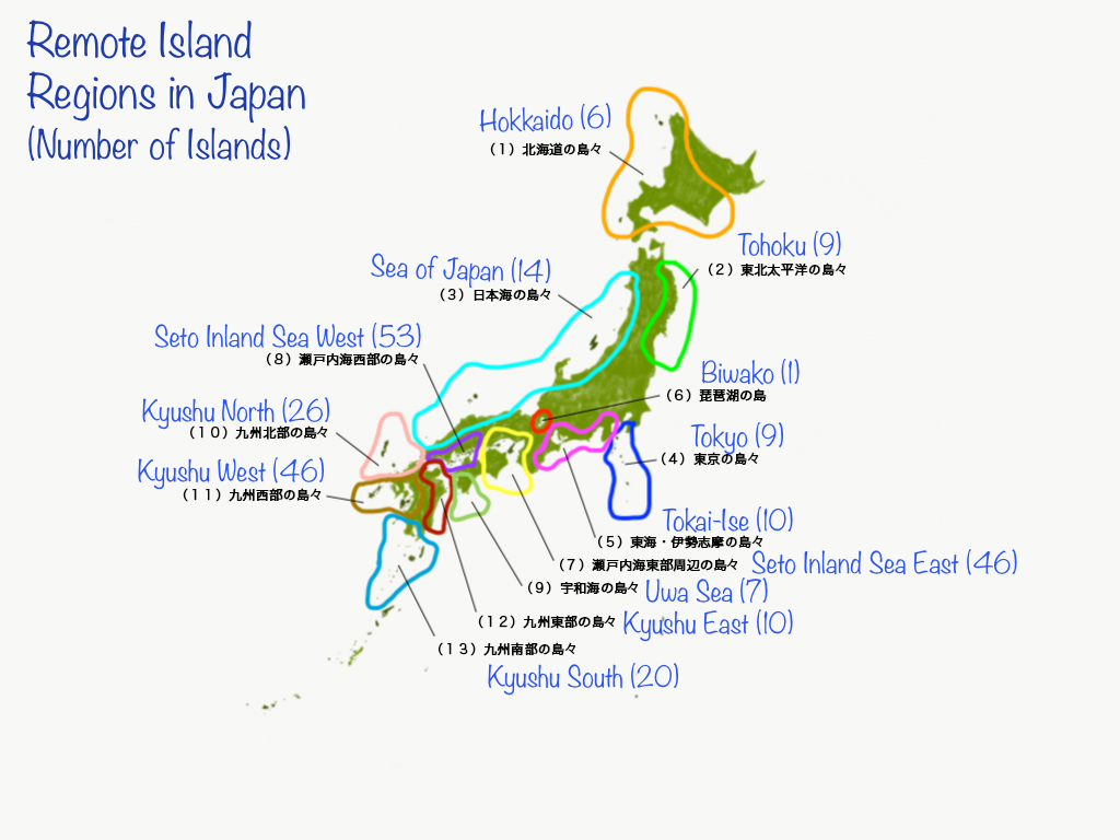
You might notice some islands near the bottom that are not highlighted by a region. I will go a bit deeper into this in another post, but the short answer is: war. The Remote Islands Development Act which defined ritō was enacted in 1953. Back then the Amami, Ogasawara, and Okinawa islands were still under US military control, thus not included. Once those groups of islands were returned to Japan each came under a different development law of their own (with significantly larger different budgets).
So, to recap, the major categories of islands include:
- The Mainland (Hokkaido, Honshu, Shikoku, Kyushu, and sometimes Okinawa)
- The exceptions (Amami and Ogasawara Islands, and sometimes Okinawa)
- The rest, aka. The Remote Islands
… with the added categorization of whether the islands are inhabited or uninhabited.
There are even more technical subcategories that I won’t get into[3] but I would like to close with a final distinction, that between the ichiji ritō 一次離島 “first order remote islands” and niji ritō 二次離島 “second order remote islands.” These are ritō that you can get to directly from one of the mainland islands, or islands that you can only get to after making a connection from one of the first order islands. This isn’t a legal distinction, just a handy one for travelling and to give a bit of a sense at how remote some of these islands actually are. There is a list of each on Japanese Wikipedia.
If you can read Japanese and would like to explore more about each of the remote islands, there is a very handy resource called 離島マップ made by @donnyi39 you can check out.
This has been a simple overview to familiarize you with the concept of ritō.
In future posts I will cover a bit more on the political importance of the ritō, their economics, and some of their challenges in the 21st century.
Some Resources
- Ministry of Land, Infrastructure, Transport and Tourism (Remote Island Development)
- Cabinet Office National Ocean Policy Secretariat
- 日本の国境に行こう!!
- Center for Research and Promotion of Japanese Islands (日本離島センター)
- Kuwahara, Sueo. “The Development of Small Islands in Japan: An Historical Perspective.” Journal of Marine and Island Cultures, vol. 1, no. 1, 2012, pp. 38–45., doi:10.1016/j.imic.2012.04.004.
- Wikipedia: 離島
- ritokei – 離島経済新聞
Footnotes
- Of those 416, only 257 are covered by the Remote Islands Development Law. This number fluctuates year to year due to the competing forces of depopulation, repopulation policies and national defense strategies. More to come on that! ↩
- Nowadays Okinawa falls into this category too. See? This gets complicated pretty quickly. ↩
- “The Third Remote Islands Development Plan (1973–1982) … classification breaks 300 islands down into 5 types based on population size, hydrographic conditions, nautical time and distance, the distance from the central city of mainland, and the geographical form of each island.” Kuwahara, pp. 42 ↩